
|
Craig Steiner, u.s. Common Sense American Conservatism |


|
|
About Me & This Website My Positions On Facebook Contact Me Articles |
Of course the maps proposed by Democrats aren't really designed to be competitive--they're designed from a partisan perspective to redraw Colorado to benefit their chances at capturing congressional seats. But assuming Democrats actually were striving for "competitive" districts, let's consider what that really means and whether it makes sense. Consider a "theoretical" Colorado where there are an equal number of rural and urban citizens. The rural area consists of a group of people in the northern half of the state with similar values and needs, and they're 100% Republican. The urban area consists of a group of people in the southern half--they too share similar values and needs and are 100% Democrat. This could be depicted such as: 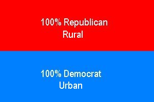 Now let's assume that Colorado is entitled to exactly two congressional districts. How should those districts be drawn? Competitiveness The Democrats in Colorado argue that the districts should be drawn to make the districts nominally competitive. That is, neither party is guaranteed to win the district because party affiliation between the two districts is very similar. Using this Democrat logic, a competitive district would be drawn as: 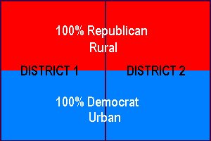 In other words, both districts are half Republican and half Democrat. This would be the "ultimate" competitive scenario where both parties have exactly the same number of voters. Is this desirable? A map such as the one above guarantees that half the state will not feel that they are well represented. If a rural Republican were to represent district 1, then half of the people in district 1 (the urban Democrats) would not feel well represented. Likewise, if an urban Democrat were to represent district 2, then half the people in the district (the rural Republicans) would not feel well represented. This map guarantees voter frustration by ensuring that half the population has representation that doesn't represent their community of interest. Representation The Republican alternative is to maximize the degree to which communities of interest are represented. Recognizing the fact that urban citizens have different needs and interests than rural citizens, everyone's representation is better if they have a representative that represents their community of interest. The Republican alternative giving communities of interest the best representation would be: 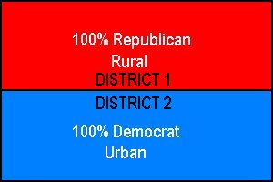 The advantage is clear. Someone who understands and lives rural issues will represent those in the rural district while someone who understands and lives urban issues will represent those in the urban district. This solution respects communities of interest and massively increases the probability that the citizen will feel (and be) well represented. Communities of Interest In the real world the contrast isn't as clear. There isn't any district that is 100% Republican nor 100% Democrat... And, everywhere, there are unaffiliated voters that are neither. And partisan affiliation is not to be a consideration when drawing congressional districts anyway. However, Colorado statue requires that the legislature (and the courts) are to make every attempt to maintain the integrity of political subdivisions (counties, cities, towns). In addition, "preservation of the most populous counties, cities, and towns shall take precedence."  Thus, if it's not possible to draw district lines in a way that avoids splitting counties, the larger counties (such as Douglas) should not be split. The smaller counties are to be split. Thus, if it's not possible to draw district lines in a way that avoids splitting counties, the larger counties (such as Douglas) should not be split. The smaller counties are to be split.Further, communities of interest (ethnic, cultural, economic, trade area, geographic, and demographic) are to be preserved within a single district. That means if Castle Rock has more in common with Highlands Ranch than Boulder, it should be placed in the same district as Highlands Ranch. Finally, disruption of prior district lines should be minimized. That means if you can solve redistricting by moving lines just a little, they shouldn't be moved a lot... or completely redrawn so that Castle Rock is suddenly in the same district as Boulder. All the maps the Democrats have proposed fail to meet virtually every statutory requirement. The Republican maps meet all requirements. Unfortunately, citizens don't have a vote on this. But if you want your voice heard, you are highly encouraged to go to the hearing on the bill on Thursday, May 5, at 2:00 p.m. in HCR 0112 in the basement of the Colorado State Capitol. If you don't think Castle Rock and Boulder have a whole lot in common, be sure to attend and let them know! Go to the article list |